Geological conditions
From a geological standpoint, the area is superposed on the external flysch area that encompasses Tarcău Unit (Sheet) and the Marginal Unit (Vrancea Sheet).
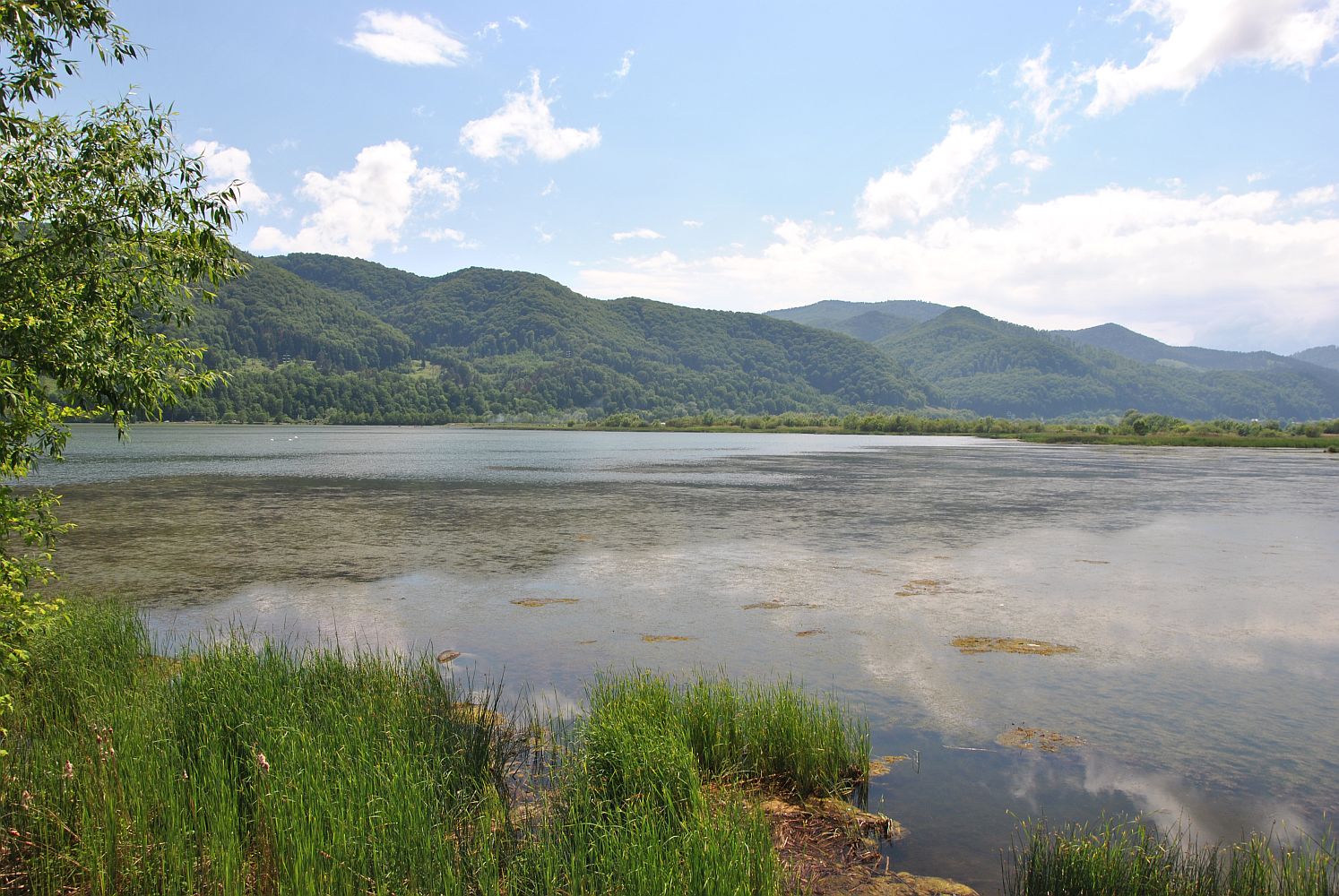
Tarcău Unit (Sheet), formed by deposits belonging to the Cretaceous and the Paleogene, appears on Bistrița Valley between Tașca and Gura Pângărăciorului localities, and is made up of two lithofacies: Tarcău-Fusaru lithofacies and Tazlău lithofacies. Pângărați Lake is situated in the valley sector superposed on the Tazlău lithofacies extended between the gullet fron Straja and Gura Pângărăciorului. The lithofacies deposits belong to the Cretaceous (Audia, Cârnu-Șiclău and Hangu Beddings) and the Palaeocene (Izvor and Straja Beddings).
Hangu Beddings, more extended in the valley sector bewteen Straja and Gura Pângărăciorului, encompass a wide variety of stones (shaly and sandy limestones, marls and clays). Being less resistant, they were more easily eroded and as such, the valley is this sector resembles a terraced depression basin.
The Marginal Unit (Vrancea Sheet) extends from Pângărăcior and Secu-Vaduri until the meeting point between the Carpathian folds (Cozla-Pietricica and Cernegura Peaks) with the Sub-Carpathians (Cracău-Bistrița Depression). The oldest deposits belong to the Cretaceous (Sarata and Lepșa Beddings), but characteristic to this unit in the inferior mountainous sector of Bistrița Valley are the Palaeocene-Eocene deposits in the Doamna-Kliwa Lithofacies (Izvor, Piatra-Uscată and Jgheabul Mare Beddings, Doamna limestones, Bisericani Beddings, Lucăcești Gritstones and Gura Șoimului Beddings). 
Geomorphology of the area
The valley sector that houses the lakes is limited to the North by Stânișoara Mountains. Stânișoara Mountains are formed by a main crest nearing 60 km and oriented north-west – south-west, from which secondary crests emerge, separated one from another by the tributary streams of Bistrița River. The average altitude of Stânișoara Mountains is of 800 m and the average energy of the relief is between 300 and 400 m. Bistrița Valley is flanked by the highest altitudes which, however, do not surpass 1200 m and decrease from the west to the east (Muncelul Pângărați, 1154 m, Simon Hill, 968 m, Prihodiștea, 806 m, Cozla Peak, 651 m,). The crest of Stânişoarei Mountains ends with Pietricica Peak, reaching a height of 528 m; it is a witness to erosion, and represents the last “bastion” of these mountains, “implated” in the sub-Carpathian Depression of Cracău-Bistrița of the territory of Piatra Neamț Municipality.
The southern part of the inferior mountainous sector of Bistrița Valley houses Goșmanului Mountains, from the east-central group of the Oriental Carpathians. They have a prolonged crest oriented from the north-west to the south-west and are mainly formed of sandy-schistose flysch. The maximum altitude of the area is 1293 m, in Murgoci Peak. Heights increase from Bistrița Valley towards the south (Hărmanului Peak – 1226 m, Murgoci Peak – 1293 m) and decrease towards the east, in the direction of the sub-Carpathian Depression of Cracău-Bistrița (Vârful cel Mare, 876 m, Cernegura Peak, 852 m).
In between Stânișoarei and Goșmanului Mountains, Bistrița Valley profoundly deepened, having the aspect of a transversal couloir formed by depression basins between Straja and Piatra Neamț, fact which is caused by rougher, mainly sandy geological formations. The slopes of the river angled between 6-17° and 17-31° are the most common, but the narrow sectors at Straja may exceed 31°. Bistrița’s valley couloir presents a wide opening at Piatra Neamț, upon drawing out from the mountain. The relief is a comparative plan to the mountainsides that limit it, and the relief formations have a fluvial origin, resultin from erosion, transport and accretion processes. The main bed of Bistrița River is raveled in many brooks, especially before the riverțs confluence with Bâtca Doamnei Lake, being accompanied by 7 levels of fluvial terraces, the inferior ones having a greater extension. The terraces are pepperd by the alluvial fans of the water courses converging towards the main course or by adobe materials coming from the slopes.
Hydrology
– Total volume: 6.75 million m³ of water at a normal retention level
– Useful volume: 2.2 million m³;
– Normal retention level: 369.6 m;
– Thalweg level: 349.7 m.
In the analysed sector, the lake receives two tributary streams do not bring significat debits of water to the lake:
– Pângăraţi River: which is 7 km in length, its hydrographic basin surface being 18 km² (of which 47.5% is represented by forests);
– Oanţu River: which is 14 km in length, its hydrographic basin surface being 40 km² (of which 70.95% is represented by forests).
The flowing regime of these rivers is characterised by low liquid debits (approximately 0.1 m³/s) during 80% of the year. During low and medium water periods, solid debits are reduced, the quantity of suspensions not surpassing 0.1 g/l, while the erosion on the surface of the basing belonging to Pângărați Lake has values spanning between 0.5-1 t/ha/year. During the spring however, when snow melts, and during the floods caused by torrential summer rains, the values of turbidity can be highly increased, reaching values of suspension quantities of 20g/l of water.
From a perspective related to the intensity of the silting process, the annually retained volume of suspensions in Pângărați Lake is approximately 300 000 m3. The intensity of the process is not uniform in the basin of the lake, being higher at the point of discharge of Oanțu River, whose alluvial fan is highly prolonged in the area of the lake.
The quality of the water is well suited for producing electrical energy, being influenced by an important water volume coming from the depths of Izvorul Muntelui Lake, after vorticity being discharged in the lake, by means of the evacuation canal. The low waters of Bistrița, however, have a more increased organic load.
From a qualitative standpoint, monitored indicators presented in the table below demonstrate a lack of major degradation sources for the water quality in the hydrographic basins that supply Pângărați Lake.
Table: Physico-chemical characteristics of the water in Pângărați Lake
| Indicator | Harvesting point 1 | Harvesting point 2 | Harvesting point 3 |
|---|---|---|---|
| Dissolved oxygen (mg/l) | 11.76 | 7.82 | 10.16 |
| Oxygen saturation (%) | 99.2 | 72.2 | 85.9 |
| Water temperature (ºC) | 5.4 | 9 | 5.5 |
| pH | 7.23 | 7.14 | 7.85 |
| Transparency (cm) | 250 | 40 | 120 |
Where:
Harvesting point 1 – entryway to the tailrace from CE “Dimitrie Leonida”
Harvesting point 2 – Bistrița River’s discharge point in the lake
Harvesting point 3 – Pângărați dam.
As such, the lowest oxygen values can be found in the discharge point of Bistrița River, but they nonetheless fall within the limits of quality class II. Electric conductivity shows a low charge both in dissolved substances and other categories of pollutants. Moreover, water vorticity is highly reduces, as the water transparency exceeds 40 cm.
On the whole, as per Order 161/2006 of the Minister for the Environment and Water Management, on the approval of the Regulations regarding the classification of surface water quality in order to establish the ecological state of water bodies, the analysed indicators are considered to be representative for a mountainous barrier lake, as the quality of the water is very good, there being no elements that may indicate a eutrophication process, with the exception of the area at the tail of the lake.
From a trophic standpoint, the lake falls under the oligotrophic category, having a very poor algaeous flora, highly oxygenated water with a low organic charge, neutral pH and moderate mineralisation. At the level of phytoplankton, the highest weight is carried by the Bacillariophyta – diatom, with its dominant species Cyclotella ocellata and Achnanthes minutissima, followed by Chrysophyta, represented by the species of the Chrysococcus genus.
– Total volume: 4.43 million m³ of water at a normal retention level;
– Useful volume: 0.43 million m³;
– Normal retention level: 349,8 m;
– Thalweg level: 323.14 m.
The lake receives two tributary streams:
– Pângărăcior River: which is 13 km in length, its hydrographic basin surface being 40 km² (of which 82.4% is represented by forests);
– Secu-Vaduri River: which is 11 km in length, its hydrographic basin surface being 27 km² (of which 69.7% is represented by forests).
The two rivers do not bring significat liquid debits to the lake. The debits are around 0.1 m³/s, while the quantity of suspensions does not surpass 0.1 g/l during 80% of the year. The volume of erosions brought from the slopes in the lake is low (0.5-1 t/ha/year), but the silting process is much intensified during spring, when snow melts, and during the torrential summer rains, when water vorticity can exceed 20g/l.
As can be seen from the table below, the quality of the water is good, but it is influenced by the important volume of water coming from upstream.
Table: Physico-chemical characteristics of the water in Vaduri Lake
| Indicator | HP1 | HP2 | HP3 | HP4 | HP5 | HP6 |
|---|---|---|---|---|---|---|
| Dissolved oxygen (mg/l) | 1.53 | 6.51 | 10.66 | 8.82 | 10.12 | 12.07 |
| Oxygen saturation (%) | 13.83 | 59.3 | 97.8 | 76.3 | 81.7 | 108.3 |
| Water temperature (ºC) | 9.1 | 9.3 | 9.6 | 7.2 | 4.5 | 8.7 |
| pH | 7.18 | 7.37 | 8.28 | 7.97 | 7.91 | 7.92 |
| Transparency (cm) | 80 | 150 | 140 | – | – | – |
Where: HR = harvesting point.
The quality of Vaduri Lake water falls under class II. At the level of oxygen regime, values characteristic to the poor ecological state caused by the organic charge of the sediments at the tail of the lake can be noticed. The input of organic substances in the shore areas is evidenced by the chemical and physical properties of the river (point 1) which drains the underground water on the left shore. The quality of the water is influenced by oozes originating from household annexes located on the shore. Water quality significantly increases as it deepens and approaches the dam. Water vorticity is much reduced, transparency exceeding 80 cm.
On the whole, as per Order 161/2006 of the Minister for the Environment and Water Management, on the approval of the Regulations regarding the classification of surface water quality in order to establish the ecological state of water bodies, the analysed indicators are considered to be representative for a mountainous barrier lake, as the quality of the water is good, there being no elements that may indicate a eutrophication process.
– Surface: 235 ha
– Total water volume: 10 million m³
– Maximum water depth near the dam is 15.5 m
Maximum extent of the lake basin surface is:
– Length 3200 m
– Width 1050 m
The main tributary stream that discharges in Bâtca Doamnei Lake on the right side is Doamna River, while upstream, at the tail of the lake, we have the tailrace of water coming from Vaduri Lake and the old course of Bistrița River.
Water debits are much reduced both on Doamna River and the old course of Bistrița River.
The quality of the water is good, being influenced by the volume of water brought from upstream through the Vaduri Lake tailrace and the two main tributary streams: Bistrița (the old course) and Doamna Rivers.
The ecological state of the water in Bâtca Doamnei Lake is good, falling under quality class II.
Climate
From a climatic standpoint, the areal pertaining to the ROSPA0125 special avifaunal protection area, Vaduri and Pângărați Lakes are situated at the contact point between the temperate region with Baltic influences, which exhibits frosty winters, rich in solid precipitations, with the region exhibiting excessive nuances.
The climate is specific to reduced height mountain regions, being characterised by annual average temperatures between 6-7°C and precipitations of 700-800 mm per year, with a dominant air mass circulation in the northern and north-eastern sectors. Daytime thermic amplitudes vary between 10-14°C during summer and 8-9°C during winter. Thermic inversions are specific during winter, when cold air is sometimes preserved on the bottom of the valley for many days. The maximum quantities of precipitations are recorded during the months of May-July, while the lowest occur during the February-March interval.
Soils
Districambisols, for that matter specific to a more acidic substrate, occur in high areas.
Soil productivity is moderately reduced, being determined by the limitations imposed by acidity, reduced edaphic volume, the frame dominated by rocks, inclination and coverage of the terrain.
Along with the establishment of the lakes, the alluvial soils in the major bed of Bistrița River were covered by water.
translated by Andrada-Cristina Dobrea